viernes, 8 de junio de 2012

La leyenda de Manco Capac y Mama Ocllo


En las tierras que se encuentran al norte del lago Titicaca, unos hombres vivían como bestias feroces.
No tenían religión, ni justicia, ni ciudades. Estos seres no sabían cultivar la tierra y vivían desnudos. Se refugiaban en cavernas y se alimentaban de plantas, de bayas salvajes y de carne cruda.
Inti, el dios Sol, decidió que había que civilizar estos seres. Le pidió a su hijo Ayar Manco y a su hija Mama Ocllo descender sobre la tierra para construir un gran imperio.
Ellos enseñarían a los hombres las reglas de la vida civilizada y a venerar su dios creador, el Sol.
Pero antes, Ayar Manco y Mama Ocllo debían fundar una capital.
Inti les confía un bastón de oro diciéndoles esto:
- Desde el gran lago, adonde llegarán, marchen hacia el norte. Cada vez que se detengan para comer o dormir, planten este bastón de oro en el suelo. Allí donde se hunda sin el menor esfuerzo, ustedes construirán Cuzco y dirigirán el Imperio del sol.
La mañana siguiente, Ayar Manco y Mama Ocllo aparecieron entre las aguas del lago Titicaca. La riqueza de sus vestimentas y el brillo de sus joyas hicieron pronto comprender a los hombres que ellos eran dioses. Temerosos, los hombres los siguieron a escondidas.
Ayar Manco y Mama Ocllo se pusieron en marcha hacia el norte. Los días pasaron sin que el bastón de oro se hundiera en el suelo.
Una mañana, al llegar a un bello valle rodeado de montañas majestuosas, el bastón de oro se hundió dulcemente en el suelo. Era ahí que había que construir Cuzco, el "ombligo" del mundo, la capital del Imperio del Sol.
Ayar Manco se dirigió a los hombres que los rodeaban y comenzó a enseñarles a cultivar la tierra, a cazar, a construir casas, etc...
Mama Ocllo se dirigió a las mujeres y les enseñó a tejer la lana de las llamas para fabricar vestimentas. Les enseñó también a cocinar y a ocuparse de la casa...
Es así que Ayar Manco, devenido Manco Capac, en compañía de su hermana Mama Ocllo se sentó en el trono del nuevo Imperio del Sol. A partir de este día, todos los emperadores Incas, descendientes de Manco Capac, gobernaron su imperio con su hermana devenida en esposa.


Leyenda de los Hermanos Ayar


Cuenta la leyenda que de “Cápac Toco”, una de las tres ventanas de la cueva Pacaritambo, en la montaña Tampu Tocco (al noroeste de Cusco), aparecieron cuatro hombres jóvenes y cuatro jóvenes mujeres, hermanas y esposas de ellos. Ayar Manco y su mujer Mama Ocllo; Ayar Cachi y Mama Cora; Ayar Uchu y Mama Rahua y finalmente, Ayar Auca y su esposa Mama Huaco.
Viendo el estado de las tierras devastadas y la pobreza de su gente, decidieron salir en busca de un lugar más propicio. Y con ellos, se llevaron diez Ayllus enrumbando al sudeste.
Ayar Cachi era el más fuerte y de cada hondazo que arrojaba formaba una quebrada o derribaba una montaña, alarmando a los hermanos por su poder. Temerosos entonces, lo convencieron de retornar a Tampu Tocco en busca de vasos de oro llamados topacusi y semillas. Lo siguieron subrepticiamente y una vez que Ayar Cachi penetró en la cueva la cerraron con bloques de piedra, diciéndole que ahí quedaría encerrado para siempre. Al escucharlos, Ayar Cachi dió gritos tan fuertes que hicieron temblar la tierra, abrirse los montes y estremecerse los cielos.
Prosiguieron su camino hasta hallar frente a ellos un Ayar Cachi dotado de alas que se posó cual un cóndor gigantesco, en la cumbre del cerro Tampu Quiro y les ordenó fundar el cusco.
Siguieron caminando hasta el cerro Huanacaure, viendo un día un arco iris cuyos extremos descansaban sobre el mismo cerro. Dijo entonces Ayar Manco a sus hermanos, que significaba buen augurio y que desde ese cerro verían el lugar donde asentarse.
En el camino los hermanos vieron una huaca y enviaron a Ayar Uchu a destruirla, pero al hacerlo quedó convertido en piedra, habiendo pedido a sus hermanos que, lo recordaran, en la ceremonia del Huarochico.
Entristecidos los hermanos continuaron su camino y bajaron hasta el pie del cerro, cerca ya del valle del Cusco. Ayar Manco envió a Ayar Auca a tomar posesión del lugar que había de poblar. Ayar Auca, de quien se dice que le habían salido alas, voló al sitio indicado y al llegar y posarse quedó petrificado también.
Sólo quedó Ayar Manco y sus hermanas quienes se establecieron luego en el Cusco, en donde se fundó el poderoso y admirable Imperio de los Incas.

sábado, 2 de junio de 2012

Ciudad del CUSCO

El Nombre De La Ciudad:
Hay cierta incertidumbre sobre el nombre correcto, en los primeros siglos de la existencia de esta ciudad importante de Sur-América precolombina, su nombre era Akamama según algunos cronistas, y según Guamán Poma de Ayala significa "Madre de la Chicha" (chicha es un tipo de cerveza de maíz fermentado).


Posiblemente era Aqhamama en la ortografía Quechua moderna "los chicha miman". Cuando esta era la Capital antigua del Tawantinsuyo, se nombro como Cusco, palabra que se traduce como "ombligo" o "centro". Después de la invasión española en 1533 el nombre se transformo en Cuzco, que en forma despectiva en el diccionario español significaba "hipócrita", "jorobado" y "perro pequeño". Esta era una manera para minimizar o satirizar el nombre de la ciudad. Después el nombre fue cambiado a Cusco, porque aquí "z" no es pronunciado como en España.
A finales del siglo XX un movimiento social muy fuerte estuvo muy deseoso de
conservar el nombre original de esta ciudad antigua; así desde el 20 de junio de 1990, la Municipalidad de la ciudad por medio del acuerdo de concilio del pueblo Nº 078-A/MC-SG-90 declaro que el nombre oficial es Qosqo.


La Población: 

La población de la ciudad del Cusco para principios del siglo XXI se proyecto para ser 300,000 habitantes. La proporción de crecimiento anual es aproximadamente 4%. En 1821 después de 3 siglos de administración colonial española esta ciudad tenia aproximadamente 40,000 personas. En el apogeo del Tawantinsuyo debe haber tenido entre 225 a 300 mil habitantes.


La Altitud: 

La altitud es de 3,400 metros sobre el nivel del mar (11,150 pies). Algunas personas no acostumbradas a la altitud suelen tener problemas por la escasez del oxigeno. Este fenómeno hace cambios a las personas que viven en las altitudes, desarrollando el corazón y hace los pulmones anchos, también su sangre contiene una cantidad más alta de células rojas. La escasez de oxigeno produce en algunas personas la enfermedad de la altitud conocida como soroche o enfermedad de Monge. Como síntomas se presentan el insomnio, dolor de cabeza, respiración lenta, dolor la parte umbral. Reflejos lentos de los tendones y puede haber pérdida de peso, deficiencia tiroidea, edema pulmonar, o infecciones. Las mujeres pueden experimentar dismenorrea o amenorrea, y muchas personas experimentan las perturbaciones psicológicas o mentales. Algunas personas les pueden tomar días, semanas o incluso anos para acostumbrarse a algunas altitudes.

La Latitud: 
Es de 13° 30' 45". Nuestra latitud indica que deberíamos tener tiempos tropicales o ecuatoriales, pero no es así. Cusco es fresco debido a su altitud.

La Longitud: 
Es de 71° 58' 33". Estamos 5 horas después del tiempo Greenwich.

La Temperatura: 
Es relativamente fresco. El promedio anual en la ciudad está entre 10.3° a 11.3° Celsius (50.54° a 52.34° Fahrenheit). Hay un poco de uniformidad aquí en la temperatura entre verano e invierno. Normalmente hace frio en la noche y durante las primeras horas de la mañana aumenta considerablemente la temperatura hasta el mediodía. Durante el mes de junio la temperatura cae frecuentemente bajo cero a 5° y 7°C (23° y 19.4°F).

La Lluvia: 
La altitud en la que se encuentra el Cusco y su proximidad a la hechura del ecuador le hace un clima especial. Hay simplemente 2 estaciones bien definidas: una estación seca y otra lluviosa. La estación seca es de mayo a octubre y la estación lluviosa de noviembre a abril. Generalmente la lluvia fluctúa entre 600 a 880 mm. Por ano que está entre 31.5 a 34.5 pulgadas.

La Humedad:
En la sección mas baja del Valle del Cusco hay un promedio de humedad anual de 64%.

El  Área

- La Republica Peruana: 1'285,215 Km² (496,221 millas²) 
- La Región Inca: 175,280 Km² (67,676 millas²) 
- La Sección de Cusco: 76,225 Km² (29,430 millas²) 
- La Provincia de Cusco: 523 Km² (202 millas²)


Alrededor de 6 mil argentinos visitaron Macchu Picchu en el mes de Abril


En el mes de Abril, ingresaron a la ciudadela inca más de 6 mil argentinos, ubicándose en segunda posición, luego de los 13.183 turistas provenientes de Estados Unidos; y seguido por los 4.063 de Brasil, Francia con 3.946 y Japón con 3.614.

USA Today, diario estadounidense señaló que Machu Picchu quedó entre las primeras increíbles aventuras para recorrer.
La publicación señala que “la aventura de ocho días sale del fuerte trekking del Camino Inca, pero no escatima en momentos importantes de inmersión cultural”, y luego añade: “puedes navegar por el curso del río Urubamba, ver los tesoros en uno de los más grandes mercados tradicionales del Perú y comer comida peruana, todo eso como preludio de dos días de exploración en Machu Picchu y los misterios del templo de la luna”.
Por otra parte, el Camino Inca ha sido considerado una de las doce mejores rutas del mundo para recorrer sin auto, según una nota publicada en la página web de la revista de turismo Budget Travel.
Este trekking sigue los pasos de los incas en el trayecto hacia la mítica y alejada ciudadela de Machu Picchu, donde los visitantes pueden apreciar una serie de restos arqueológicos, así como una gran variedad de flora y fauna.
En el texto también se indica que en la ruta se aprecian escaleras de piedra que conducen a los bosques nublados, hasta que finalmente las nubes desaparecen y la “enorme Puerta del Sol revela la ciudad de piedra increíblemente conservada”.

Expertos de la UNESCO señalan que no hay signos de alarma


Los expertos de la UNESCO que llegaron a Machu Picchu para inspeccionar el santuario histórico, han confirmado que la Ciudadela Inca “no presenta ningún signo de alarma” en su conservación, sin embargo, presentaron un documento con algunas recomendaciones para su preservación.
El Ministerio de Cultura mediante un comunicado de prensa en el que Nuria Sans, la directora de la UNESCO para América Latina y el Caribe, señaló que se debe mejorar el desarrollo urbano de Machu Picchu Pueblo, lugar de acceso a la ciudadela.
Expresó, que se necesitan ciertas seguridades en relación al crecimiento desordenado de Aguas Calientes, aclarar cuáles son los papeles de los responsables del santuario respecto a la legislación internacional y comunicar cuáles van a ser las acciones”.

Machu Picchu Sanctuary Lodge elegido entre los mejores para pasar la luna de miel


La revista estadounidense “Brides”, dirigida especialmente a las novias y que brinda asesoría sobre la boda, la luna de miel y consejos para la vida en pareja; eligió al Hotel Machu Picchu Sanctuary Lodge, ubicado junto a la ciudadela inca, como el segundo hotel mejor de Centro y Sudamérica para pasar la luna de miel.
En la elección participaron unos 7.000 agentes de viaje que votaron por los que consideran son los mejores hoteles, resorts e islas para lunas de miel.

Machu Picchu Sanctuary Lodge was chosen as the second best hotel in Central and South America to pass the honeymoon


The U.S. magazine "Brides", directed particularly to brides and provides advice on the wedding, honeymoon and tips for married life; elected to the Hotel Machu Picchu Sanctuary Lodge, located next to the Inca citadel, as the second best hotel in Central and South America to pass the honeymoon.


In the election participated some 7,000 travel agents who voted for those who believe are the best hotels, resorts and islands for honeymoons.

COMUNICADO

domingo, 11 de diciembre de 2011

Otros atractivos turísticos cerca a Machu Picchu

Mercado de Pisaq 

Ubicado en Pisaq a 30 km. De Cuzco, es uno de los mercados de artesanía más grande del Perú.


El Mercado de Pisaq es un mercado dominical (aunque funciona casi diario), es un punto de encuentro de los pobladores de las comunidades locales; quienes vienen a  presenciar la misa en quechua, socializar y a vender o intercambiar mercancías.
Pisaq, al igual que otros poblados fue una ciudad española donde se fusionaron tradiciones europeas con Incas que permanece en pie hasta hoy desde el día de su fundación en el siglo 16. Con el tiempo Pisaq se ha convertido en un importante centro de producción artesanal y ha alcanzado la fama de tener uno de los mercados artesanales más grandes de Latinoamérica.


Ciudadela de Pisaq


De mayor extensión que Machu Picchu y a la vez tan impresionante como esta, Pisaq fue una ciudadela Inca formada por 6 áreas diferentes ubicadas al pie de las montañas y con una vista privilegiada al Valle Sagrado. Incluye un sistema de caminos, acueductos, muros Incas, andenería y portales de piedra.


Aquí disfrutará de una impresionante caminata, lo llevaremos hasta la cima de la colina donde está ubicada la ciudadela y podrá explorar los diferentes complejos arquitectónicos y notar las diferencias de estilo entre unos y otros además de sorprendentes obras de ingeniería y arquitectura. Su transporte lo estará esperando en la Plaza de Armas de Pisaq, para cuando baje a través del sistema de terrazas a un extremo de la ciudadela. Realmente vale la pena dedicar 2 a 3 horas para esta visita.


Urubamba


Esta ciudad es posiblemente el área urbana más importante del Valle Sagrado. Sus habitantes son en su mayoría agricultores y comerciantes que se dedican al cultivo y venta principalmente de maíz además de otros productos agrícolas. Sin embargo en los últimos años Urubamba se ha convertido en un pueblo con mucho comercio y negocios turísticos como hoteles, restaurantes, discotecas, deportes de aventura, entre otros, trayendo prosperidad a la ciudad sin trastocar mucho su espíritu rural.


Ollantaytambo


La única ciudad Inca donde muchos de sus habitantes aún viven en las antiguas edificaciones Incas que datan de siglos atrás.

Aquí podrá apreciar calles y viviendas Incas casi intactas, un gran templo edificado con enormes piedras en un estilo arquitectónico muy fino y una especie de santuario con canales y caídas de agua. Ollantayatambo tiene también su estación de tren donde se puede partir a Machu Picchu en vez de hacerlo desde Cusco.


Es considerada una obra monumental de la arquitectura incaica. Es la única ciudad del incanato en el Perú aún habitada. En sus palacios viven los descendientes de las casas nobles cusqueñas. Los patios mantienen su arquitectura original.


Aguas Calientes


Por su localización geográfica (a escasos 30 minutos en autobús de Machu Picchu) es el lugar por el que llegan en tren desde la ciudad imperial aquellas personas que desean visitar las ruinas por lo que el desarrollo de su infraestructura turística y hotelera ha sido notable, sacando ventaja de las montañas y verdosos paisajes de la zona. 


Entre sus atractivos turísticos más importantes se encuentran los baños termales situados a 800 m del pueblo a los que se les atribuyen propiedades medicinales y que dan nombre al mismo. 


Awanacancha


Es una granja de camélidos sudamericanos donde podemos apreciar llamas, alpacas, vicuñas y guanacos de distintas razas; se ubica en el camino a Pisaq en un antiguo campo agrícola de tiempos incaicos que ha sido restaurado y habilitado para la crianza y exhibición de estos camélidos.

Dentro del Awanakancha existe una exhibición permanente de tejidos en alpaca donde familias locales hacen demostraciones de todo el proceso de confección textil, desde la esquila de los auquénidos, pasando por el lavado de la lana, el hilado, teñido de las fibras hasta el acabado final de las piezas. Puede además aprovechar de adquirir prendas de alpaca de gran calidad en la tienda ubicada en el mismo lugar.


Chinchero


Ubicada a 30 km. al Noroeste de Cusco en la cima de una meseta a 3650 m. de altura.

Chinchero fue uno de los asentamientos Incas y coloniales mas grandes de la zona y en la actualidad aún se pueden apreciar muestras de ambas arquitecturas, como andenes Incas, restos arqueológicos, la Plaza de Armas y la iglesia del siglo 26, además de un mercado artesanal dominical especializado principalmente en textiles, donde tendrá la oportunidad de interactuar con familias dedicadas al ancestral arte de la textilería. 


Moray


Es un conjunto de terrazas en forma de círculos concentricos donde se cree que los Incas realizaban experimentos agrícolas, debido a las condiciones especiales del lugar, tales como diferentes tipos de tierra, vientos, humedad, clima y abastecimiento de agua distintos en cada una de las terrazas. Debido a la gran diversidad de flora y fauna, la adaptación de especies en distintas zonas era un reto constante para los antiguos peruanos.

En las cercanías de Moray se han encontrado varios almacenes con excelentes condiciones de ventilación y ambientes extremadamente secos que demuestran como los antiguos peruanos usaban estos sitios a manera de congeladores para preservar comida por largos períodos de tiempo. Esta es una de las técnicas conocidas más antiguas para la preservación de alimentos.


Salinas de Maras

Son unas salineras provenientes de brotes de agua salada subterránea que es almacenada en varios reservorios individuales donde es puesta a secar para ser posteriormente extraída por pobladores locales. 


domingo, 28 de agosto de 2011

Machu Picchu Travel Information (VERSIÓN EN INGLES)


Machu Picchu

machupicchu


LOCATION
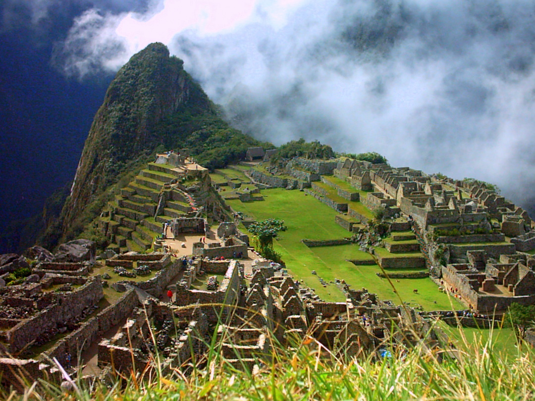
The Machupicchu archaeological complex is located in the department of Cusco, in the Urubamba province and district of Machupicchu. It is perched on the eastern slopes of the Vilcanota mountain range, a chain of mountains curtailed by the Apurimac and Urubamba Rivers. At latitude 13º7' South and longitude 72035' West of the Greenwich Meridian, Machupicchu is located at a height of 2,350 meters above sea level (main square).


CLIMATE AND ENVIRONMENT
It is located in a subtropical zone, or dense wood, the reason why the climate is mild, warm and damp, with an average year-round temperature of 130C during the day. One can perceive two distinct seasons during the year: the rainy season from November to March, which is a time of heavy rains. Visitors are advised to dress accordingly during this season. The dry season from April to October brings on higher temperatures.


FLORA AND FAUNA
orquideaBoth are abundant and varied. Typical plant life in the historic reserve of Machupicchu includes pisonayes, q'eofias, alisos, puya palm trees, ferns and more than 90 species of orchids.
The fauna in the reserve includes the spectacled bear, cock-of-the-rocks or "tunqui", tankas, wildcats and an impressive variety of butterflies and insects unique in the region.
The lie of the land, the natural surroundings and the strategic location of Machupicchu lend this monument a fusion of beauty, harmony and balance between the work of the ancient Peruvians and the whims of nature.

HISTORY

history
One cannot pinpoint the first to populate these lands, as it was a time of occupation rather than foundations. Machupicchu was visited by explorers well before Hiram Bingham, although with little success. These included Antonio Raymondi, the Count of Sartiges and Charles Wiener. Other visits included one in July 1909 by the Santander brothers, whose inscription can be found carved into the base of the Temple of the Sun. At the same time, Peruvian explorers Enrique Palma, Augustin Lizárraga and Gavino Sánchez arrived at the citadel by the route of San Miguel.
The railway line runs parallel to the river in winding loops that follow the riverbed. From here one can seethe typical vegetation of the upper jungle, which climbs up to the top of the steep mountain range that forms the Urubamba Canyon. The train passes through the Chilca train station from where one can see the snowcapped peak called "Veronica". With a height of 5,750 meters above sea level, it is the highest peak in the Urubamba range. The train stops at Kilometer 88, where the Inca Trail begins.

The train then continues on its way, passing through the station of Pampacahua and the town of Aguas Calientes, located at Kilometer 110. When the train line comes up against a wall of imposing granite mountains, it then plunges into two tunnels before arriving at the station of Puente Ruinas. From here, minibuses take the travelers up 8 kilometers of roads up to the Tourist Hotel. The entry control to the Inca citadel is done near the hotel.


GUIDED TOURS
The guided tour of Machupicchu starts on a path that leads from the bus terminal. The path, built on purpose for tourism, enters the citadel in the section that houses a cluster of rooms near the outer wall. The path continues through a terrace to gain access to the agricultural zone before arriving at the urban area.


ARCHITECTURE
arquitecturaThe citadel is divided into two sectors: the agricultural (terracing) and the urban, where there are main squares, temples, palaces, storehouses, workshops, stairways, cables and water fountains which run through both sectors, which measure 20 and 10 hectares respectively.
It is clear that the architectural design was based on Cusco, the capital of the Inca empire. Machupicchu was built according to its natural surroundings, with its constructions following the natural curves and dips and rises in the land.
.
The archaeological excavation that took place after Bingham discovered the ruins showed the land was previously given granite foundations with little surrounding soil.
The agricultural and urban sectors are split by a dry ditch, the result of a geographic fault line.
The following chapters describe the most important constructions in each sector.


THE AGRICULTURAL SECTOR

The sector is surrounded by a series of terraces of different types and sizes which had two main functions: to grow crops and halt the erosion caused by the rains. The most eye-catching terraces lie at the entrance to the citadel. They begin at the cluster of rooms located at the entrance and climb up to the top of the mountain until they stop at a large rectangular room.It is clear that the upper terraces at the entrance were meant for agricultural purposes as they have raised steps and are much wider. The lower terraces, meanwhile, have different shapes because they were built as foundations.
There are no canals as they were not necessary, as the constant rains and ever-present humidity allowed the plants to grow without irrigation. The only water channel that flows through the urban sector crosses through the central terrace.
In the agricultural sector there are five rooms that look like Chincheros and Ollantaytambo storerooms.


THE CONTROL GATE

This is made up of a three-walled room with a view with several windows, which can be found in front of the main gateway. There is a go panorama from here of the agricultural and urban sectors and the surrounding landscape. It is a good idea to take photos from this angle as it gives the visitor a good view of the complex.


THE UPPER CEMETERY AND RITUAL STONES
gate

In every Inca city, the dead were buried on the outskirts of the town, which is where in this case Cusco archaeologists found human remains. In the upper part, they also found sculpted stones that belong to the area, which indicated the Incas used the stones to make offerings to their gods. On this same piece of ground lies a granite boulder sculpted with steps. But the most striking feature is that it is pierced with a ring, the purpose of which is unknown. This ritual boulder is very similar to that of the ñusta-hispana in the Vilcabamba I ruins. In the upper part one can see a body-shaped spot as if people had been placed on their backs.


THE URBAN SECTOR

While the agricultural sector is cut short by a dry ditch, one can see a long stairway that leads to the front gate.
This sector houses the most important constructions of any Inca city, where one can appreciate the talent, effort and quality of the pre-Hispanic builders, as the constructions are entirely made of granite, a very hard rock that is different from that used in Cusco.
The city is U-shaped. In the northern section there is the great religious sector containing the temples, to the South there are the houses and workshops on platform terraces that Bingham called the Military Group. The main buildings in the Urban Sector are the following:


THE TEMPLE OF THE SUN

This construction is shaped like a semi-circle and built on solid rock, an existing granite block shaped to blend with the natural curves, with a diameter of 10.50 meters. It is composed of highly polished polyhedrons. There are two trapezoidal windows in this building with protruding knobs at every comer, and on the north side there is a carefully-sculpted door with bored holes in the doorjamb, very similar to the Qoricancha temple in Cusco. The Spanish historians relate there were once gold and precious jewels encrusted in the door. To the West of the temple there is a rectangular patio with nine ceremonial doorways alternating with prism-shaped studs. 


THE INTIWATANA

reloj solar
This stone is located on a hill made up of several terraces. The visitor can gain access to the stone via 78 well-crafted steps. At the end of the staircase one enters an open patio with walls equally well-sculpted, and where one can see an upper platform where there is a granite rock sculpted into three steps. In the central part one can see a rectangular prism that is 36cm high and which is pointing from North-West to South-East.
Its four corners are directed to the four cardinal points. The Intiwatana had specific functions: it measured time (the solstice and the equinox) by using sunlight and shadow, and also served as an altar. In Quechua, "Inti" means "sun" and "Wata" means "year", thereby giving us the meaning of a solar year observatory.


THE GROUP OF THE SACRED ROCK

The sacred rock, located in a four-sided spot flanked by two three-sided rooms, features a monolithic rock sculpture which is 3cm high and 7m wide at its base. The pedestal, which is approximately 30cm high, resembles a feline. From another angle, It looks like the profile of a mountain near Machupicchu. It is possible that this cluster of constructions, together with two "Wayranas", or three-sided rooms, were used for rituals.


THE TEMPLE OF THREE WINDOWS

It is located West of the main square, has a large rectangular floor. Its name comes from the fact its main face has three windows and two blind bays. Together with the main temple, this is the most impressive architecture in all of Machupicchu. The enormous polyhedrons have been carved and joined with millimetric precision.
In front of the Wayrana-style construction, on the large doorjamb next to the central column that holds up the roof, there is a sculpted lithograph with carefully polished molds and flat parts.


MAIN TEMPLE

The temple is located North of the Sacred Square, very near the Temple of Three Windows. It is built of three walls and is 11m long and 8m wide.


THE DOORS

Doors are a common sight in Machupicchu and especially in this sector. They vary in texture, size and architectural style that set them apart from each other, although all have the same trapezoid shape. Some only have one doorjamb and lintel, and some have two. Some doors are simple and others have different security mechanisms such as stone rings, central trunks and other mechanisms which served to tie together beams to make the doors more secure.


THE FOUNTAINS

To the South of the complex, between the Temple of the Sun and the Royal Palace, the area houses a series of water fountains, the only sources of the vital element for the residents of Machupicchu. The first three water fountains or "PaqchaS7 in Quechua, have been extremely well sculpted. The architectural structures in this area are basically sculpted rock to which are added other decorations such as the spillway and the side walls. This beautiful finish is due to the harmony existing between the Temple of the Sun and the Royal Palace. These fountains were fed by underground water and carried via a canal to be used for irrigation of crops.


THE TOMB

The enormous leaning block of stone that holds up the Temple of the Sun has a large crack in its bottom part, which has been exceptionally skillfully decorated and furnished to be later used as a tomb.
It was also a site of worship and offerings to the mummified bodies of the main authorities. In the doorway it shows a carving portraying the symbol of the goddess Mother Earth. In its interior there are niches, monolithic pillars and other accessories used for religious means and to attend the mummies.


THE SQUARES

There are four main squares at different levels, but share the characteristic of being rectangular in the classic Inca style, interconnected by sunken stairways in the parameters of the terraces. The main square is the largest, which just like the main squares in all Inca cities, had religious and social functions.
The fourth open area is a square flanked by terraces with their respective access ways, similar to the 1,000 B.C. Chavin culture.
On July 14, 1911, Hiram Bingham arrived together with a team of Yale University specialists in topography, biographies, geology, engineering and osteology, led by local inhabitant Melchor Arteaga. They asked him about the city, and he told them it was located on top of an old peak ("Machupicchu" in Quechua).
Later, in 1914 Hiram Bingham returned to Machupicchu with economic and logistic backing from Yale University and the U.S. Geographic Society with the specialists mentioned above, whose report was published and made available around the world with the title "The Lost City of the Incas".
In the original map, Bingham carved Machupicchu into sectors according to the four cardinal points. Some names have remained the same, but 76 years after the discovery of Machupicchu, scientific studies carried out by archaeologists from the archaeological foundation of the National Cultural Institute as well as delegations of foreign scientists, have provided valuable conclusions about the use and functions of the buildings. These were based on archaeological excavations and the architectonic relations between the buildings with similar construction across the vast Inca empire.
The periods of occupation have been broken down into the following, based on historical accounts, construction style and ceramics:

1. Initial (up to 1,300 A.D.)
2. Classic (up to 1,400 A.D.)
3. Imperial (up to 1533 A.D.)
4. Contact or Transition (1533 to 1572)


DESCRIPTION OF THE ROUTE TO MACHUPICCHU

There are 112krn of railway line between the city of Cusco and the station of Puente Ruinas or Machupicchu. The trip starts in the station of San Pedro in Cusco, zig-zagging up the Picchu mountain until it reaches the highest point, a spot called "El Arco" (the arch), in the northwest part of the city.
- The route then descends to the villages of Poroy, Cachimayo and lzcuchaca until it reaches the Anta plains, an extensive cattle area. It climbs down the gully of Pomatales before descending to the Sacred Valley of the Incas, arriving at the station of Pachar. The route then crosses the Urubamba River to the right bank and arrives at the station of Ollantaytambo. For those who arrived here by the asphalt road of the Sacred Valley, one can board the train to continue to Machupicchu.


HOT SPRINGS:

At a distance of 800m East of the town of Aguas Calientes, there are underground hot sulfur springs which bubble up from the rocky ground at varying temperatures.
The especially-built pools at this resort are the basis of its use as hot mineral baths. The average temperature of the water runs from 38ºc to 46ºc. There are also changing rooms, bathrooms and a small snack bar.


RAIL TRANSPORT

Tourist Train, It only operates in the high season, leaving Cusco in the morning, stopping at the most important stations (Ollantaytambo, Km.88 or Ooriwayrachina) until it arrives at the station of Puente Ruinas. The trip takes four hours and returns in the evening.

Autovagon, This tourist service leaves Cusco in the morning and takes three hours. The trip from The Sacred Valley of the Incas (Urubamba to Ollantaytambo) takes 1,1/2 hours. It returns in the evening.
It is recommended to check all timetables in train stations and travel agencies, as they are modified according to the season.

sábado, 27 de agosto de 2011

Fotografías de Machu Picchu

Templo de la Ciudadela


Huayna Picchu


Llamas en Machu Picchu


Colcas en Machu Picchu


Intihuatana solar


Las Tres Portadas


Templo del Sol


Machu Picchu


Celebraciones por el Centenario de Machu Picchu para el Mundo


Ceremonia incaica Tinkay (parte 1)


Ceremonia incaica Tinkay (parte 2)


Iluminación de Machu Picchu